The Petroleum Club of Shreveport, 15th floor
Cost: $20, Children 10 and under $8
We encourage members to invite guests, spouses, and friends to any of our meetings.
If you’d like a seat, kindly use the form below to make your reservation by the preceding Friday.
Biography

Henry W. Posamentier
Henry W. Posamentier is a Geological Consultant recently retired from Chevron Energy Technology Company. He currently consults for numerous companies worldwide, focusing on lithofacies prediction risk issues. Prior to joining Chevron in 2007, he was with Anadarko Petroleum Corporation where he served as Chief Geologist. Earlier he was with the Atlantic Richfield Co. (1991-2000), Exxon Production Research Co. and Esso Resources Canada, Ltd. (1979-1991), and at Rider University, Assistant Professor of Geology (1974-1979).
Dr. Posamentier's research interests have been in the fields of sequence stratigraphy, seismic stratigraphy, seismic geomorphology, and depositional systems analysis, where he has published widely. Most recently, he has employed an interdisciplinary approach to the predication of lithofacies distribution through time and space by integrating stratigraphy, geomorphology, and depositional systems analysis, using 3D seismic visualization integrated with borehole data. In 1971-1972, Dr. Posamentier was a Fulbright Fellow to Austria. He has served as an AAPG Distinguished Lecturer to the United States (1991-1992), an AAPG Distinguished Lecturer to the former Soviet Union (1996-1997), an AAPG Distinguished Lecturer to the Middle East (1998-1999), and an AAPG Distinguished Lecturer to Europe (2005-2006). In 2008 he was awarded the Pettijohn Medal for excellence in sedimentology from the Society for Sedimentary geology (SEPM), in 2010 the William Smith Medal for contributions to applied and economic aspects of geology from the Geological Society of London, and in 2012 the Robert R. Berg award for outstanding research from AAPG.
Abstract
As high-quality 3D seismic data has become widely available, our ability to predict the subsurface distribution of lithologies has significantly improved. Stratigraphic interpretation of seismic data involves the integration of stratigraphy and geomorphology, with integrated section and plan view images yielding robust interpretations of stratigraphic architecture and associated lithology. With the investment of billions of dollars in acquisition and processing of seismic data, realizing the value of that investment by extracting maximum information from these data is business-critical. Being able to predict lithology prior to drilling can reduce exploration and development risk significantly and therefore has the potential of increasing substantially the chances of drilling success and reducing costs in the process.
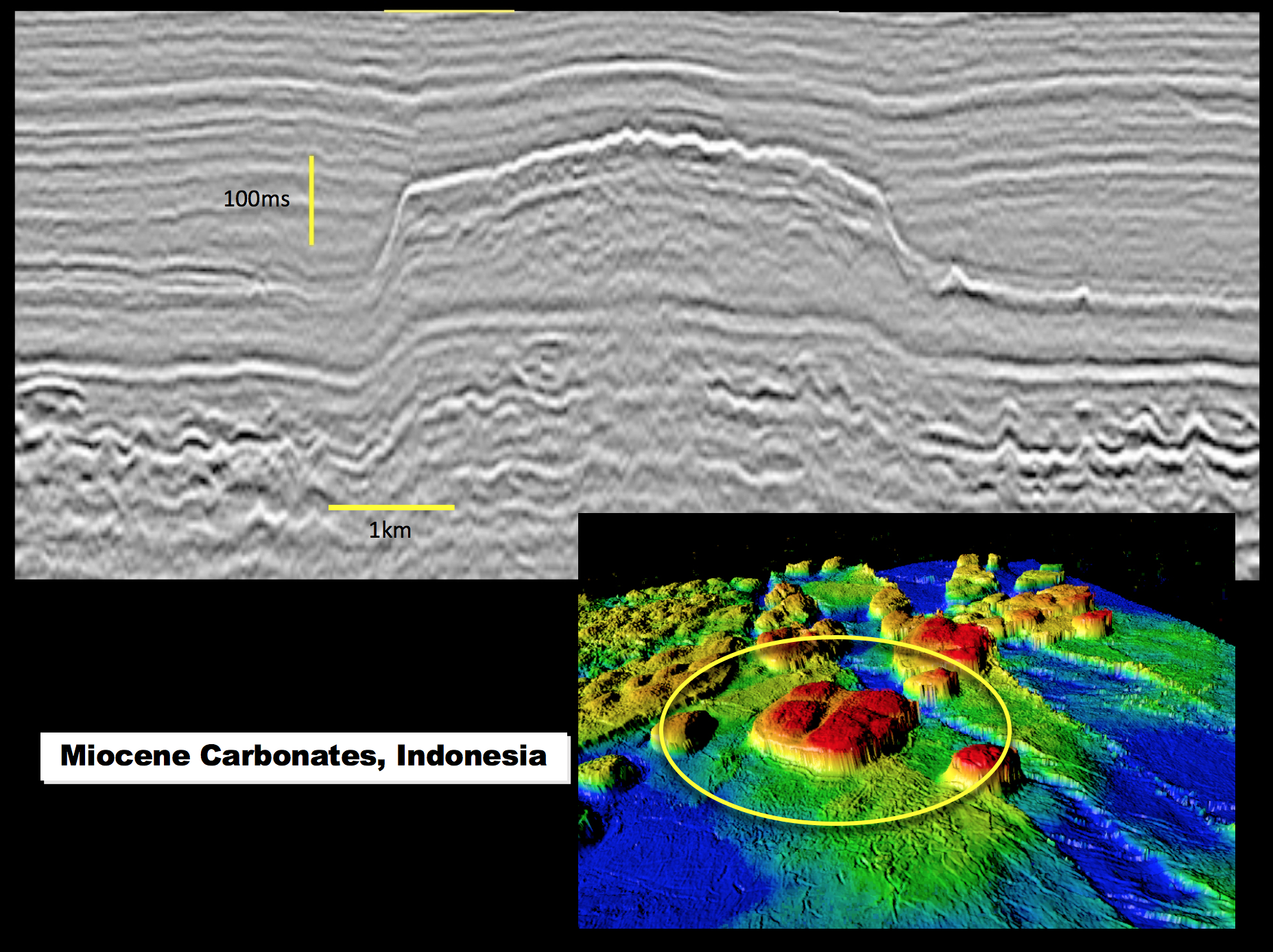
Geologically-meaningful seismic patterns can be recognized in multiple domains, including section views, plan views, 3D perspective views, and animated (i.e., movie) views. Once such patterns have been identified, interpreters can then populate these patterns with appropriate lithologies. Seismically-derived geologic interpretations can have significant impact on exploration and production in the following ways:
Geology: 1) prediction of lithology, 2) prediction of compartmentalization, 3) development of depositional analogs, 4) Enhanced understanding of geologic processes. Through a variety of techniques, it is possible, in many instances, to image significant parts of depositional systems. Components of depositional systems, i.e., depositional elements such as channels, patch reefs, etc., are then identified and yield insights as to the lithology of these deposits. Subsequently, further analysis can provide insights as to stratigraphic compartmentalization.
Geophysics: 1) provides depositional context for geophysical analyses (e.g., DHI analysis, reservoir properties from seismic). Understanding geologic context can provide a “reality check” when evaluating geophysical data for rock and fluid properties. 2) Quality control for geophysical processing. Evaluating the quality of seismic images, especially in the plan view domain, of known geologic features can help determine the value of a given processing step. Ensuring that meaningful geologic features are not processed out of the data is critical to maximizing the value of seismic data.
Examples will be shown from deep-marine as well as shallow-marine and non-marine environments, illustrating how patterns observed from multiple seismic domains can lead to robust geologic interpretations and predictions of lithology. Critical workflows designed to efficiently “mine” 3D seismic data also will be illustrated.